State: Wyoming
Address 1: 15 Ash, Boysen Route
City: Shoshoni
Zip: 82649
Phone: (307) 876-2796
Open: Open all year
Open all Year: Yes
Number of Sites: 280
Camp URL: http://wyoparks.state.wy.us/Site/SiteInfo.asp?siteID=2
Full Hook: Yes
Boysen State Park offers 3 entrances: U.S. Highway 20 (east side), U.S. Highway 26 (south side) and Bass Lake Road (west side).
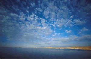
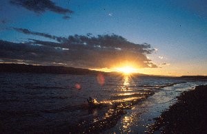
Boysen State Park is one of the larger parks in the State Park System. It is a lake-orientated park at the south end of the Owl Creek Mountains at the mouth of Wind River Canyon now part of the Wind River Canyon Scenic Byway. It offers a variety of water type recreation. Day and camping facilities are available. It features interesting geological formations. Several state record fish have been caught out of the reservoir.
Winter Services… We are open year-round with limited services in the winter season. All of our water systems, except for Brannon are closed from the middle of September to the middle of April.
Camping Areas:
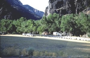
Lower Wind River: Located in Wind River Canyon below the dam along the Wind River by the tunnels. It is the site of the original Boysen Dam. There are several shade trees, grass, and interesting geological features, and a group shelter that can be reserved for special functions. Local Big Horn Sheep herd often sited. There are approximately 50 sites of which 24 are reservable.
Upper Wind River: This campground is located just below the dam next to the Wind River. It has approximately 50 sites of which 10 are reservable. It has several level spots. There are several shade trees and lots of grass. Several interesting geological features are nearby. Big Horn Sheep often visible by the dam.
Brannon and Tamarask: Both campgrounds are at the north end of the reservoir. There is a boat launching area. A commercial concession provides visitors with a complete marina service. There is a protected bay for tying up boats, a sandy beach, some shade trees and picnic shelters. There are approximately 65 sites. Close access to lake.
Tough Creek Campground: Tough Creek is located on a peninsula. It has a boat launching area and a small reservable group shelter. It has several level areas. There are some shade trees and picnic shelters. Close access to the lake. There are approximately 65 sites.
Loop 1: Can be found on the west side of the reservoir and consists of several small camping areas with limited camping: Fremont Bay, Libby Point, Sandy Hills Loop and South Muddy. There is a boat launching area, a reservable group shelter for special functions, some picnic shelters, and a few level spots. There are a few shade trees. Close access to the lake. There are approximately 20 sites.
Loop 2: Loop 2 is also on the west side of the reservoir with limited camping in several camping areas: North Muddy, Sand Mesa, Wilson Bay, Trout Bay and Cottonwood Bay. There is a boat launching area, a small reservable group shelter, some picnic shelters, a sandy beach and a few shade trees. Close access to the lake. There are approximately 30 sites.