State: Maine
Address 1: From Machias, take Route 1 to Route 191 in East Machias. Turn right and proceed 16.9 miles
City: Cutler Village
Phone: 207-941-4412
Open all Year: Yes
Number of Sites: 3
Camp URL: http://www.maine.gov/cgi-bin/online/doc/parksearch/details.pl?park_id=44
Full Hook: Yes
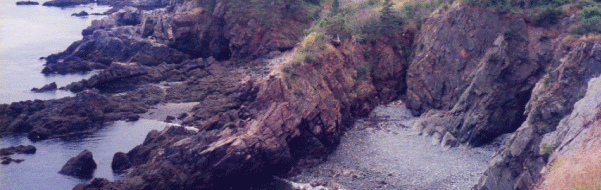
Those seeking a taste of wilderness along Maine’s coast will enjoy exploring the Cutler Coast Public Lands, a 12,234-acre expanse of blueberry barrens, woodlands and peatlands with 4.5 miles of headlands (interspersed by pocket coves and cobble beaches) overlooking the Bay of Fundy. Hikers can enjoy 10 miles of trails, three remote tent sites and spectacular views from the property’s steep cliffs-part of the dramatic “Bold Coast” that extends from Cutler to Lubec.
Cool, damp and windy conditions along the coast tend to stunt tree growth and favor species that normally would occur in alpine and sub-alpine terrain such as Hooker’s iris, bird’s eye primrose and baked appleberry. Birders have recorded nearly 200 species on or near the Cutler Coast. According to www.mainebirdingtrail.com, warblers, chickadees, golden-crowned kinglets and six species of owls frequent the woods, while seabirds and ravens nest along shoreline ledges. Offshore, from early summer to early fall, visitors may spot seals, porpoises and occasional humpback, finback, northern right and minke whales.
Activities
ATV riding
birdwatching; picnicing; boating
camping
hiking (trails)
hunting
watching wildlife
Trails
The coastal portion of the property has hiking trips from 3-10 miles. Wear sturdy footwear and take care near cliffs and on boardwalks, particularly in damp and slippery conditions. The estimated trail times listed below assume a leisurely pace in good conditions with brief stops.
Coastal Trail to Ocean (2.8-mile roundtrip, allow 2 hours) A forested path that runs through a cedar swamp and maritime spruce-fir forest before reaching a promontory overlooking the ocean. This is the easiest trail segment: the remainder is moderately difficult.
Black Point Brook Loop (5.5-mile roundtrip, allow 4-5 hours) Wooded trails and rocky cliffside hiking lead to a small cobble beach at Black Point Cove (accessible via a log ladder). The return route, via the Inland Trail, is somewhat rocky but over fairly gentle terrain.
Fairy Head Loop Trail (9.1-mile roundtrip, allow 6-7 hours)
This trail provides the most extensive shorefront hiking with 3.8 miles that skirt the shore. At Fairy Head, the trail turns inland through open meadows and forest, passing by a freshwater grass marsh and a large beaver pond.
On the forested northern portion of the property, across Rt. 191, there are 19.5 miles of shared-use roads and designated ATV trails, many of them maintained by the East Stream Trail Riders ATV Club. A portion of this system passes through the Ecological Reserve: please remain on the trail to protect the Reserve grasslands and fragile peatbog ecosystems.
Cliff tops are often undercut and can be dangerous (particularly in wet conditions). Stay on the trail and supervise children closely.
The three permitted campsites are 4-5 miles from the parking lot. Carry in food, water and camp stoves (campfires are prohibited).
On Maine’s public lands, some timber harvesting is done to generate revenues for property stewardship. Potential harvest areas at Cutler lie north of Route 191 and are clearly signed if active.