State: Maryland
Address 1: 1431 Potomac Camp Road
City: Oakland
Zip: 21550
Phone: (301) 334-2038
Number of Sites: 22
Camp URL: http://www.dnr.state.md.us/publiclands/western/potomacforest.asp
Full Hook:
National Park: null
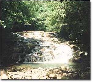
The Potomac State Forest, 11,535 acres situated between the towns of Oakland and Westernport and partially bordering the Potomac River, is reached from Maryland Routes 135 and 560. Mountain forests, streams and valleys make up nearly 12,000 acres in Potomac State Forest. The forest drains into the Potomac River Basin, and features the highest point in any Maryland state forest Backbone Mountain, elevation 3,220 feet. Another high point in the forest is the rock outcropping near the intersection of Maryland Route 135 and Walnut Bottom Road which overlooks a portion of Potomac State Forest, Savage River State Forest and Crabtree Creek.
The Potomac River has its headwaters in this rugged mountain forest where wildlife abounds and there is excellent trout fishing.
State Forest regulations are posted in conspicuous locations throughout the forest. Additional information and a brochure can be obtained by calling the forest headquarters.
CAMPING AREAS
Wallman/Laurel Run: South of Oakland, along Wallman and Laurel Run Roads leading to North Branch of Potomac River (16 sites).
15 Laurel Run Rd., Oakland, MD 21550
Lostland Run: Near headquarters area, along Lostland Run road leading to North Branch of Potomac River (6 sites).
1701 Potomac Camp Rd., Oakland, MD 21550
Primitive Camping Along Forest Roads: One Group Site and one Shelter Site per area, along with roadside sites. Group Sites (up to 20 persons) must be reserved in advance. All other sites are “first come, first served”. Self-registration at camping area. Call Forest Office for reservations at 301-334-2038.